< Share | Follow >
Members of our family have vacationed in the Cays of Abaco, Bahamas since the 1950’s. Despite the threat and fear that we experienced in this story, Abaco is a safe, family friendly area populated by welcoming locals. We’ve never had a threatening confrontation in Abaco. To be clear, the incidents described in this story occurred 80 miles west of Great Abaco in Grand Bahama waters 10 miles from Freeport.
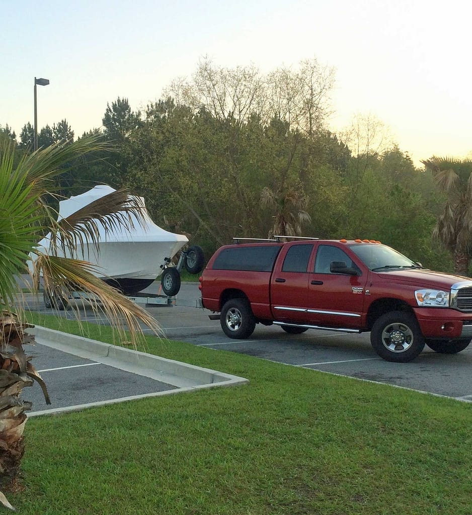
Since buying his boat 5 years ago (2009) taking it to the Bahamas was high on Eric’s bucket list. The trip had been researched and planned over a span of three years. In fact, there had been three years worth of aborted attempts due to scheduling conflicts, engine problems and Hurricane Sandy. This year, the 26 foot, center console boat, Pirate Dog, with her new twin 200 HP Yamaha 4-stroke outboards was ready to go.
Eric and I are on the verge of launching a new Rum business. Rumson’s Rum. In August we’ll begin selling Rum. Things are about to get very busy and April looked like the last window of opportunity to check that Bahama boat adventure off the bucket list. Heck, a boat trip to the Bahamas could even be considered work related. There’s no shortage of beach bars and rum drinks in the Bahamas.
In the 1950’s, my wife’s grandparents bought the north end of Man-O-War Cay, a section of the island known as Corn Bay, in Abaco, Bahamas. We absolutely loved the place and would visit every chance we had. After college we began bringing friends along to Corn Bay.
Eric and I have been friends since nursery school. We have lots of shared adventures. Vacationing at Corn Bay became a mutual passion.
Eric loved it as much as we did and he became a regular. In 2001 He brought his girlfriend, Sharon. As fate would have it, Sharon also fell in love with Abaco, and apparently with Eric too because three years later they were married in Hopetown on Elbow Cay.
Sadly for me and my family, Corn Bay was sold in 2002 and although we were very happy to return to Abaco for Eric and Sharon’s wedding, the loss of our island paradise was hard. We didn’t return for 10 years. (Pinterest photos: Paradise Lost)
So here we are, 10 years later, 2014. Eric is committed to trailing his boat from NJ to FL and taking it to the Bahamas. Just as I came on board to help launch the Rumson’s Rum business, I came on board as first mate for this adventure.
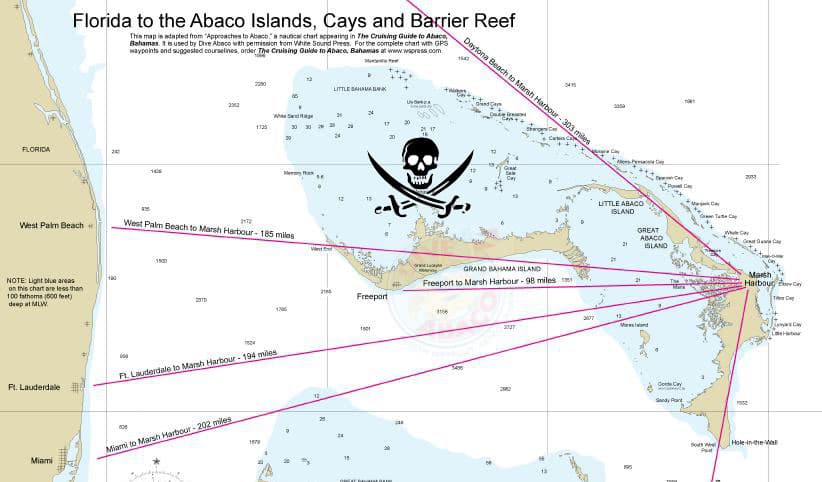
It wasn’t a very complex plan. Attach the boat trailer to the truck, get on route 95 South in NJ and follow it to Jupiter FL. Drive the boat 58 miles East, across the gulf stream to West End on Grand Bahama Island (boat miles are stated as nautical miles.) Clear customs, buy beer and gas at West End and continue just south of east for another 150 miles to Hopetown.
Ordinarily, vacationing in the Abacos requires a flight to West Palm Beach or Fort Lauderdale, FL, then a small plane ride (propeller) to Marsh Harbor airport on Great Abaco Island. You can either rent a boat in Marsh Harbor or take the Albury’s Ferry Service to Hopetown on Elbow Cay. This is how the rest of the vacation crew were getting to the Bahamas. Four adults and four kids constituting three different families, none of them mine, were scheduled to arrive at the appointed pickup place, Snappas (fun bar/restaurant on the water) where we would meet them with the boat.
A special note of thanks to my very understanding and supportive wife Sig for permitting this adventure without her. The convincing argument being that it was “work” related.
The thing about going to the Bahamas by boat, different than flying, is that it is largely weather dependent. The date was fixed as Monday, April 14th that “the gang” would arrive in Marsh Harbor and we would be there to pick them up in the boat. The rental house also became available on Monday, April 14th. That meant sleeping on the boat for any number of days that we arrived early in the Bahamas. Did I mention this is a 26 foot center console boat?
We needed to watch the weather carefully to make sure we were in FL and ready to go when it was in our favor. We had been monitoring the forecasts daily for a month. It looked like Thursday or Friday April, 10th or 11th would work. (These were our most relied upon forecasts: www.passageweather.com and www.barometerbob.org.)
Boating in the open ocean in a 26 foot boat needs to be approached cautiously. In the middle of the Gulf Stream, you’re 27 miles from the nearest point of land. The Gulf Stream is a current traveling from the south to the north. Any north wind can create very uncomfortable and dangerous swells. In fact, a strong wind from any direction can create seas that are hazardous for small craft.
In addition to watching the weather, we researched other hazards and prepared the boat accordingly. We had redundant GPS for navigation. We had fixed and portable VHF radios for communication. We had two sets of flare guns. We had a self inflating life raft. We had life vests. We had an EPIRB (Emergency Position Indicating Radio Beacon) and a Personal Locator Beacon. We had food and water and a packed “ditch bag.”
As part of our “risks” research, we learned that the twin Yamaha 200 HP, four stroke engines that powered Pirate Dog were the highest targeted item for marine theft. Their speed and reliability are ideal for “go fast” drug or human trafficking boats (yes, it turns out human trafficking is a pretty big problem.) To protect the engines, we used an engine lock device making it impossible to raise or straighten them so that the boat could not be towed. And by impossible, I mean it would slow down a thief in the middle of the night.
What we chose not to bring was a firearm. I’m licensed in MA to carry a concealed weapon and bringing a firearm and ammunition into the Bahamas is permissible if declared at Customs. Instead of a gun we brought a hickory shaft from a sledge hammer and we figured we could employ the flare guns and fish gaff if necessary.
We had heard of incidences of piracy in the Bahamas but felt that we were traveling in a low risk area. We agreed that introducing a gun into any potential confrontation would increase our chances of ending up dead. There are however, plenty of boaters and fisherman that wouldn’t leave port without their weapons readily accessible. Just read this thread about Weapons on Boats in the Bahamas. Our experience has altered our thinking.
The drive from NJ to Jupiter FL was surprisingly easy. Eric drove so maybe easier for me? Driving 1,200 miles, roughly 18 hours in 1 1/2 days, towing close to 36 feet of trailer and boat is sort of an adventure in its own right. We left NJ at 9:00 AM, drove 15 hours (lots of traffic in MD and VA) and parked behind a restaurant between two hotels at 12:30 AM for a few hours of sleep in Georgia. Eric had loaded a twin mattress in the truck bed and I sort of stretched out across the back seats. For five hours of sleep, a hotel seemed overkill plus, “roughing it” seemed to fit with the overall spirit of the trip.

Up and on the road at first light, by way of Waffle House, had us arriving at Burt Reynolds Park in Jupiter, FL by 4:00 PM (Friday, 4/11/14). Again we camped in the truck at the Park anticipating a quiet, restful night and a pre-dawn start.
The noise and activity of fisherman coming and going at all hours of the night came as a surprise. Of course this was a Friday night and there are a lot of passionate fishermen in Jupiter. Parking in a more remote area, in hindsight, would’ve been a better choice.
I’d be remiss at this point not to mention the voracious disposition of Jupiter NoSee’ems (tiny, almost invisible, biting bugs) at dawn. The boat was still encased in it’s winter shrink wrap and as we stripped, packed and readied it for launch, we were under constant harassment.

The weather forecast was for east wind building to 15 mph but light through 9AM and seas ranging from 2-3 feet. Not perfect but safe. We were underway before 8AM, passing the Jupiter Lighthouse and exiting the inlet in calm seas. Within 1 mile offshore we were well into the 2-3 foot seas and light wind, both on our nose. We were experiencing some pounding but with a cruising speed of 23 mph it was a fun ride.
Excuse the bumpy video but this was shot at about the midpoint between Jupiter and West End. The impact from a wave midway through is what causes me to drop the camera momentarily. This is the “smooth sailing” part of the trip. Another video later on shows what we were heading into.
Entering a new country from the U.S. by boat requires that you display a yellow quarantine flag indicating that you have yet to clear customs. We docked at the Old Bahama Bay fuel dock, which is conveniently also the Customs Dock, with our quarantine flag hoisted. Fees were paid, passports were stamped and we had officially arrived in the Bahamas. Now it felt like we were on vacation. Naively we thought the hard part of the trip was done.
While refueling we inquired about where to buy some beer. We should certainly toast our arrival right? Well, beer is over a mile away in the settlement. A persistent soul aware of our predicament convinced us that he could bicycle to the store, obtain the beer and be back before we were done fueling. I gave him a $20 for a six pack and off he rode. Apparently, the price of a six pack was $20 so I was obliged to give him another $5 to express my gratitude.


With Kalicks in hand, 30 minutes after arriving, we were motoring out of Old Bahama Bay harbor. Keeping up the charade that we were over the “hard part” of the trip, we were able to cruise at a speed of over 35 mph in gorgeous, shallow, azure blue water. This lasted for the first 3 miles of the remaining 150.
We were right back into that headwind from the east and the corresponding 2-3 foot waves. 25 mph seemed to be the maximum speed that allowed good forward progress without constantly slamming the hull. To give perspective, you could not stand in the boat without grasping a rail.
Twice after particularly jarring hull slams, the overhead cabinet door flew open. The second time spilling a random assortment of stuff into the boat and into the water. We picked up batteries, tissues, engine paperwork, instrument covers and we circled back trying to recover what went over board. Now I’m not sure if this was a bit of foreshadowing but one of those items was a hand painted pirate flag. To be fair, it was a dog pirate flag. Okay, to be exact, it was a flag of the Pirate Dog boat logo which has also evolved to be the logo for Rumson’s Rum. Certainly worthy of backtracking to fish out of the water.


The overhead cabinet now securely locked, we continued on toward our next way point, Mangrove Cay. Once again beyond the sight of land we begin to realize that the 58 mile leg across the Gulf Stream was actually going to seem like the shortest leg of the journey.
The toll on the knees and lower back from five hours of absorbing shock was becoming apparent but the warm sun, gorgeous turquoise water and the sight of land on the horizon cancelled any discomfort. Time seems to pass more quickly when you can gauge your progress watching a speck of land increase in size and take shape as an actual Cay.
Our course had us traveling along Grand Bahama Island heading 1 mile north of Mangrove Cay. There is nothing at Mangrove Cay but scrub. It’s uninhabited. There’s good anchorage and it’s on the main cruising corridor. Feeling a sense of accomplishment reaching Mangrove Cay and knowing we had another 22 miles to our next way point of Great Sail Cay, I convinced Eric to stop for a minute. We only had time for that first beer because it was too rough to drink underway but still, I was in need of some release (we wouldn’t be drinking and driving anyway).
As I was taking care of business we noticed another center console boat traveling across our stern, heading south east and running toward Grand Bahama. The only other boats we had seen since leaving FL were sailboats in the very far distance or large sport fishing boats also way in the distance. We felt a little relief seeing another small, similar boat out on the water. We hadn’t noticed the other boat approaching and it made us wonder where they came from.
Great Sail Cay was another 22 miles to the East. We knew that passing Great Sail would represent the halfway point in miles and it was already 2 PM. We had burnt through six hours since leaving Jupiter.
We stopped just long enough to pee and we were just about to get back underway when we saw that other boat changing course and coming back toward us. We could see the driver and two other men on board and they were hailing our boat. They were waving their arms overhead trying to get our attention … which they had.
It’s unusual at sea to approach another vessel without cause or invitation. We were flying a Bahamian courtesy flag above our American flag so it was apparent that we were Americans visiting the Bahamas. Something about their change of direction, their direct approach and their hailing didn’t feel right. Clearly, they weren’t in distress or in need of assistance, but it was obvious that they wanted us for something. The custom is for all boaters to monitor VHF channel 16. Theirs was definitely a boat that would have a VHF yet they made no effort to contact us.
We had resumed our heading toward Great Sail traveling at the same rate as before, roughly 24 mph. Instinct is an interesting thing. In a unique situation when two individuals have the same gut instinct about a situation, it’s usually right. Our gut was telling us to get out of there and that no good would come from letting this aggressive boat approach us. They were bearing down hard and were less than 100 yards away when we hit the throttles. This would be the test. They had been heading straight towards us and approaching quickly. They adjusted their course and were now running parallel with us still about 100 yards to the south but closing the gap.
At this point, our minds are racing. Clearly we’re being pursued. The least likely scenario was that they needed assistance or wanted to be social so they were trying to catch up. We ruled out this explanation. The next most likely scenario was that they wanted to sell us drugs. That seemed plausible.
Remember how we’ve been traveling into a headwind and 3 foot swells? Remember how we had found that cruising at a speed of 24 mph seemed to allow for maximum headway without brutal hull slams into oncoming waves? Well, the boat speed is now over 34 mph. We’re either in the air, free falling or crashing with great impact through steep swells. We’re hanging on tight and it feels like we’re on the edge of control. This is equally punishing to the boat and our bodies.
Eric agrees with me that if they wanted to sell us drugs, our actions have clearly demonstrated that we’re not interested so the question remains, why the hell are they still chasing us? At this point we go through our inventory of potential weapons … hickory shaft, flare guns, fish gaff, and we feel incredibly vulnerable.
We identified our pursuers first as “the other center console boat.” When they began to chase us we re-identified them as “drug dealers.” Both boats at this point are enduring a painful pounding. It’s obvious that they are very motivated to catch us. We’re now convinced that they’re “Pirates.” These dudes mean to, at the very least, rob us, but more likely, they mean to take our boat.
Their interception course has now placed them behind us by a couple hundred feet and they’ve begun to chase us directly in our wake. We wondered if this was giving them a “smooth water” advantage. We never got a clear look at what kind of power their boat had but we knew this was now a race.
All I can say is “thank god” that the twin Yamaha 200 HP, four stroke engines that were powering Pirate Dog, were allowing us to gain distance from our pursuers. We spent the next 20 minutes holding on tight, looking over our shoulders and praying nothing broke loose or went wrong. I can only think that they were praying for the opposite because they continued the chase even as the gap between us grew. We had probably traveled close to 10 miles before they broke off and headed back to, we presume, Grand Bahama or Freeport???
While we made our escape, the “what ifs” were lingering and haunting. It was an experience that was hard to shake. I’m jumping ahead here but as we shared our story over the next couple days with some very seasoned Bahamas cruisers (sail boats) the comments we heard were:
- “We always carry a firearm with plenty of ammunition and a willingness to fire first”
- “In a situation like that they don’t leave survivors.”
Trying to look on the bright side, we made really good time between Mangrove Cay and Great Sail Cay and it wasn’t too much further to Little Abaco Island. Something about entering Abaco brought a greater sense of safety or security. We continued to look over our shoulders but we always had a view of Little Abaco as well as the smaller Cay’s whose names were familiar to us. On the not so bright side, literally, we had driven into heavy clouds and increasing winds. In fact, the wind, still on our nose was steady at over 20 knots.
After bumping along through nasty, choppy water and wet weather for another two hours, we had one last navigationally challenging hurdle to face. There are two possible routes available, each with unique challenges. To get around Whale Cay you can either go through very shallow water on the south side where you really need to visually identify some prominent rocks or, you can go out into the open Atlantic Ocean to the north of Whale Cay. There’s plenty of deep water to the north but the Whale Cay Cut, entering back into the Sea of Abaco, becomes very treacherous with breaking waves. There was no way to get a current update on passage conditions but the GPS was already programmed so we headed out into the Atlantic.
The whole loop heading out and around Whale Cay represents about 5 miles. To great relief, the swells were not breaking. They were spaced very close together and were averaging 8-10 feet making the ride very exciting. We slowed down to about 15 mph and plotted our course carefully. Everything on the horizon would disappear as we powered up the steep face of each wave. Over the hump, we’d have a brief moment of equilibrium before our descent brought our stare straight into the sea. And so it went for the next 1/2 hour. This video doesn’t come close to capturing the ride. It was shot before entering the Whale Cay Cut, right after we decided that would be our route. We’re not traveling very fast so what you’re hearing is the wind which had to be at a steady 25-30. We were drenched, head to toe. Mostly salt water coming over the bow and port rail but, in the spirit of the day, the weather was throwing plenty of fresh rain water into the mix.
Exactly 10 hours had passed as we pulled into Hope Town harbor at 6:11 PM, Saturday, 4/12/14. We went straight to the Harbor’s Edge restaurant. Within 4 minutes of securing the boat to the dock I had finished a Bahama Mama and was well into my first Kalick. As I sat at the table I realized that we skipped dinner on Friday night, ate no breakfast or lunch on Saturday and a single can of Kalick had provided all hydration. It had been a long day.


Our motto for Rumson’s Rum is “Exceptional Rum for Spirited Folks, With Stories to Share.” We celebrate treating life as an adventure and we appreciate sharing the stories of those adventures with good and new friends over fine spirits. Our wet and salty appearance didn’t go unnoticed. People approached and slowly we began to share the stories.
The vacation that followed our big adventure was what you might expect. The “gang” arrived. The houses were perfect. Excellent days of boating, snorkeling, surfing and swimming ensued. Much rum, beer and Cuban cigars were enjoyed. Many fun beach bars and restaurants were visited. Stories were shared and created.
Before I end this tale I’ll share three more things. First, the adventure would not have been complete without the experience of two nights sleeping in Hope Town harbor on Pirate Dog. She was perfectly comfortable if not a little cramped. You can see my side of the Vee in the photo.


Spending 2 days on the boat allowed us to inspect for any damage that occurred during the journey. The bench seat for the driver can be down for sitting or up for leaning. Because of the pounding we were taking, we had the seat up. When the hull would crash particularly hard, leaning against the seat was helping us with the compression. Early in the trip we felt and heard the seat crack in the center. The now flexible nature made it clear that we had broken it in the middle.

The other obvious damage involved the 2 inch diameter, aluminum tubing which forms the T-Top. Fine cracks can be seen in most of the welds but the top cross piece on the starboard side broke in half. I’ve circled it in red in the picture. Besides that and a bunch of loose screws, thankfully, the boat is in fine condition.
The second item I’ll share is that Eric did try to report our encounter to Bahamian authorities via internet and email. We were able to give a formal statement to the newly appointed Constable, Officer Mackenzie, following a chance meeting at Nipper’s Beach Bar and Grill. A detailed account of our experience was recorded and posted as a “Report of Suspicious Behavior” as no crime was actually committed. Constable Mackenzie, coincidentally, had just assumed his position on Great Guana Cay being relocated from Grand Bahama Island. He was very familiar with West End and Freeport and their populations. He suggested that our bicycle, beer courier shared information about us, our boat and our destination on his trip to town. He suspected that our pursuers were in fact Pirates, and probably carried automatic weapons.


The third and final item I’ll share here, about this experience, is that the return trip to Florida was the exact opposite. It took 6 hours, we traveled at a rate of 47 mph and the water was like a mirror.

Please feel free to leave relevant comments or questions and to share this story.
Cheers,
Steve (right)

Anyone planning a trip to Abaco Bahamas, The Cruising Guide is an indispensable resource.
Loved reading this! Heard the story from
Eric awhile back 😊
Comments are closed.